
Towards Efficient Roadside LiDAR Deployment: A Fast Surrogate Metric Based on Entropy-Guided Visibility
36th IEEE Intelligent Vehicles Symposium (IV 2025), Cluj-Napoca, Romania, 2025年6月22日
arXivDOI: 10.1109/IV64158.2025.11097554
3行要約
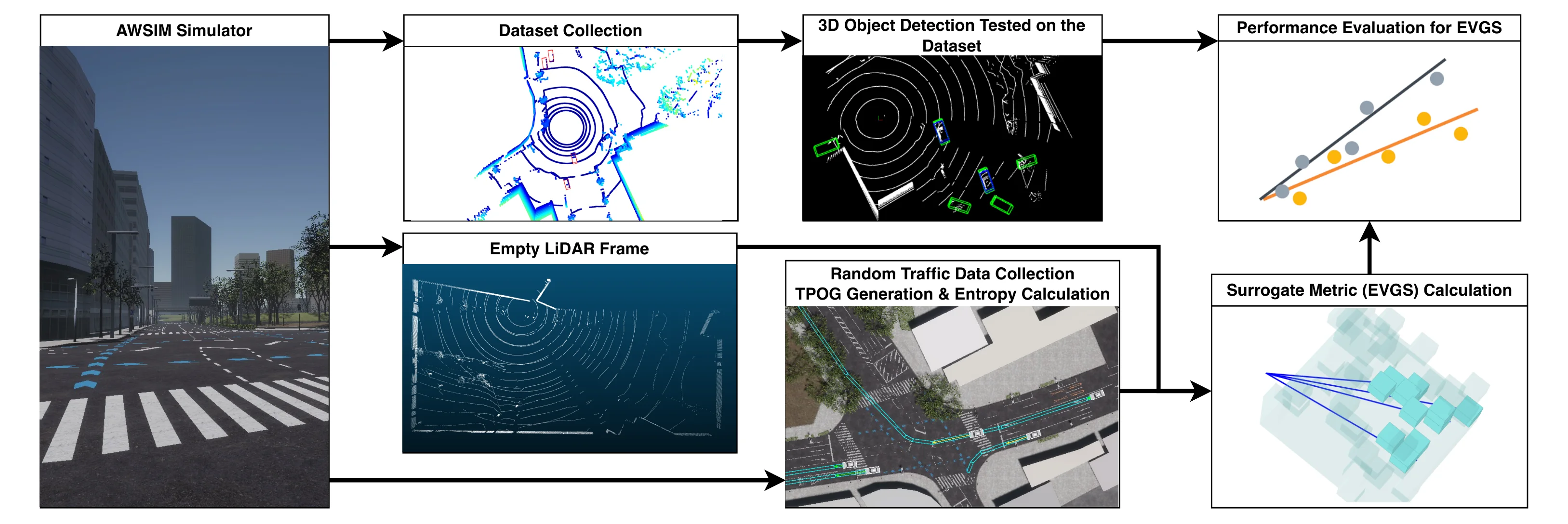
- 路側LiDARの設置候補を比較するため、エントロピーに基づく視認性スコアを提案する。
- 車両が占有しやすい領域を確率的な占有格子で重み付けする。
- スコアは検出の平均適合率と相関し、候補ごとに物体検出を実行する手間を減らす。
論文の図
アブストラクト(原文)
The deployment of roadside LiDAR sensors plays a crucial role in the development of Cooperative Intelligent Transport Systems (C-ITS). However, the high cost of LiDAR sensors necessitates efficient placement strategies to maximize detection performance. Traditional roadside LiDAR deployment methods rely on expert insight, making them time-consuming. Automating this process, however, demands extensive computation, as it requires not only visibility evaluation but also assessing detection performance across different LiDAR placements. To address this challenge, we propose a fast surrogate metric, the Entropy-Guided Visibility Score (EGVS), based on information gain to evaluate object detection performance in roadside LiDAR configurations. EGVS leverages Traffic Probabilistic Occupancy Grids (TPOG) to prioritize critical areas and employs entropy-based calculations to quantify the information captured by LiDAR beams. This eliminates the need for direct detection performance evaluation, which typically requires extensive labeling and computational resources. By integrating EGVS into the optimization process, we significantly accelerate the search for optimal LiDAR configurations. Experimental results using the AWSIM simulator demonstrate that EGVS strongly correlates with Average Precision (AP) scores and effectively predicts object detection performance. This approach offers a computationally efficient solution for roadside LiDAR deployment, facilitating scalable smart infrastructure development.
関連ニュース
引用方法
Y. Jiang, E. Javanmardi, M. Tsukada, and H. Esaki, “Towards Efficient Roadside LiDAR Deployment: A Fast Surrogate Metric Based on Entropy-Guided Visibility,” in 36th IEEE Intelligent Vehicles Symposium (IV 2025), Cluj-Napoca, Romania, 2025, doi: 10.1109/IV64158.2025.11097554.
BibTeX
@inproceedings{Jiang2025,
  title         = {Towards Efficient Roadside LiDAR Deployment: A Fast Surrogate Metric Based on Entropy-Guided Visibility},
  author        = {Yuze Jiang and Ehsan Javanmardi and Manabu Tsukada and Hiroshi Esaki},
  url           = {https://arxiv.org/abs/2504.06772},
  doi           = {10.1109/IV64158.2025.11097554},
  year          = {2025},
  date          = {2025-06-22},
  urldate       = {2025-06-22},
  booktitle     = {36th IEEE Intelligent Vehicles Symposium (IV 2025)},
  address       = {Cluj-Napoca, Romania},
  abstract      = {The deployment of roadside LiDAR sensors plays a crucial role in the development of Cooperative Intelligent Transport Systems (C-ITS). However, the high cost of LiDAR sensors necessitates efficient placement strategies to maximize detection performance. Traditional roadside LiDAR deployment methods rely on expert insight, making them time-consuming.  Automating this process, however, demands extensive computation, as it requires not only visibility evaluation but also assessing detection performance across different LiDAR placements. To address this challenge, we propose a fast surrogate metric, the Entropy-Guided Visibility Score (EGVS), based on information gain to evaluate object detection performance in roadside LiDAR configurations. EGVS leverages Traffic Probabilistic Occupancy Grids (TPOG) to prioritize critical areas and employs entropy-based calculations to quantify the information captured by LiDAR beams. This eliminates the need for direct detection performance evaluation, which typically requires extensive labeling and computational resources. By integrating EGVS into the optimization process, we significantly accelerate the search for optimal LiDAR configurations. Experimental results using the AWSIM simulator demonstrate that EGVS strongly correlates with Average Precision (AP) scores and effectively predicts object detection performance. This approach offers a computationally efficient solution for roadside LiDAR deployment, facilitating scalable smart infrastructure development.},
  keywords      = {ITS},
  pubstate      = {published},
  tppubtype     = {inproceedings}
}