
Accurate Cooperative Localization Utilizing LiDAR-equipped Roadside Infrastructure for Autonomous Driving
27th IEEE International Conference on Intelligent Transportation Systems (ITSC 2024), Edmonton, Canada, Sep 24, 2024
arXivDOI: 10.1109/ITSC58415.2024.10920101
Summary in three lines
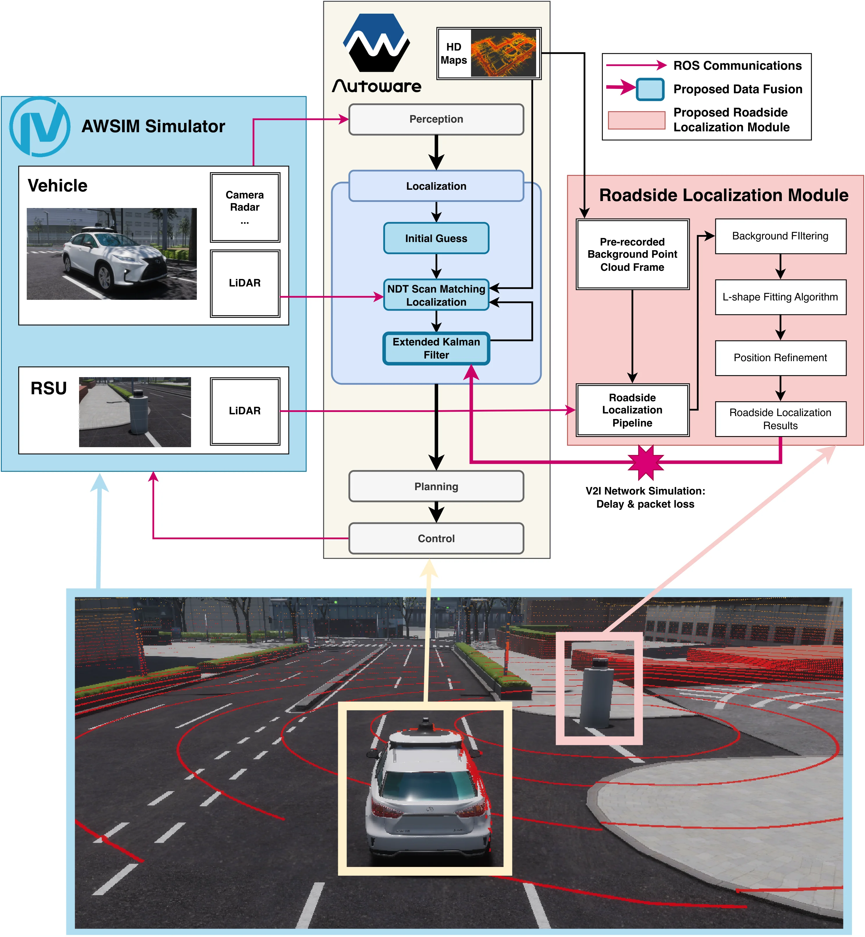
- The method augments onboard localization using LiDAR measurements from roadside infrastructure.
- Vehicle dimensions refine the position estimates sent from the roadside.
- Tests found up to 80% better accuracy than standalone NDT in difficult settings, and examined delay and packet loss.
Figures from the paper
Abstract
Recent advancements in LiDAR technology have significantly lowered costs and improved both its precision and resolution, thereby solidifying its role as a critical component in autonomous vehicle localization. Using sophisticated 3D reg- istration algorithms, LiDAR now facilitates vehicle localization with centimeter-level accuracy. However, these high-precision techniques often face reliability challenges in environments devoid of identifiable map features. To address this limitation, we propose a novel approach that utilizes road side units (RSU) with vehicle-to-infrastructure (V2I) communications to assist vehicle self-localization. By using RSUs as stationary reference points and processing real-time LiDAR data, our method enhances localization accuracy through a cooperative localization framework. By placing RSUs in critical areas, our proposed method can improve the reliability and precision of vehicle localization when the traditional vehicle self-localization technique falls short. Evaluation results in an end-to-end autonomous driving simulator AWSIM show that the proposed method can improve localization accuracy by up to 80% under vulnerable environments compared to traditional localization methods. Additionally, our method also demonstrates robust resistance to network delays and packet loss in heterogeneous network environments.
Related news
How to cite
Y. Jiang, E. Javanmardi, M. Tsukada, and H. Esaki, “Accurate Cooperative Localization Utilizing LiDAR-equipped Roadside Infrastructure for Autonomous Driving,” in 27th IEEE International Conference on Intelligent Transportation Systems (ITSC 2024), Edmonton, Canada, 2024, doi: 10.1109/ITSC58415.2024.10920101.
BibTeX
@inproceedings{Jiang2024b,
  title         = {Accurate Cooperative Localization Utilizing LiDAR-equipped Roadside Infrastructure for Autonomous Driving},
  author        = {Yuze Jiang and Ehsan Javanmardi and Manabu Tsukada and Hiroshi Esaki},
  url           = {https://arxiv.org/abs/2407.08384},
  doi           = {10.1109/ITSC58415.2024.10920101},
  year          = {2024},
  date          = {2024-09-24},
  urldate       = {2024-09-24},
  booktitle     = {27th IEEE International Conference on Intelligent Transportation Systems (ITSC 2024)},
  address       = {Edmonton, Canada},
  abstract      = {Recent advancements in LiDAR technology have significantly lowered costs and improved both its precision and resolution, thereby solidifying its role as a critical component in autonomous vehicle localization. Using sophisticated 3D reg- istration algorithms, LiDAR now facilitates vehicle localization with centimeter-level accuracy. However, these high-precision techniques often face reliability challenges in environments devoid of identifiable map features. To address this limitation, we propose a novel approach that utilizes road side units (RSU) with vehicle-to-infrastructure (V2I) communications to assist vehicle self-localization. By using RSUs as stationary reference points and processing real-time LiDAR data, our method enhances localization accuracy through a cooperative localization framework. By placing RSUs in critical areas, our proposed method can improve the reliability and precision of vehicle localization when the traditional vehicle self-localization technique falls short. Evaluation results in an end-to-end autonomous driving simulator AWSIM show that the proposed method can improve localization accuracy by up to 80% under vulnerable environments compared to traditional localization methods. Additionally, our method also demonstrates robust resistance to network delays and packet loss in heterogeneous network environments.},
  keywords      = {ITS},
  pubstate      = {published},
  tppubtype     = {inproceedings}
}