
Towards Cooperative Automated Driving: Geographic-Aware Network Analysis and Visualization tool
17th Asian Internet Engineering Conference (AINTEC 2022), Poster, Dec 19, 2022
Summary in three lines
- The tool measures connected vehicles’ network performance together with geographic information.
- It visualizes packet loss, bandwidth, and jitter in real time.
- A proof-of-concept outdoor experiment took place on the University of Tokyo’s Hongo campus.
Figures from the paper
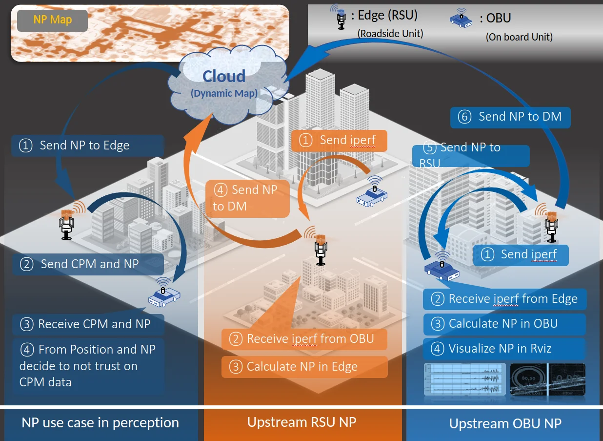
Abstract
In recent years the cooperative automated vehicle (CAV) concept has been gaining attention due to its potential to increase traffic safety and traffic flow by utilizing the vehicle-to-everything communication capability. One of the key requirements for CAV is ensuring every vehicle receives relevant messages at the right time and place; therefore, measuring and visualizing network performance is vital. However, for CAV applications, more network analyzers than those extant are needed because these do not consider geographical characteristics. In this study, we proposed a geographically-aware CAV-specific network analysis and visualization tool that can report the network performance factors such as packet loss, bandwidth, and jitter in real time. Further, we developed a proposal tool and evaluated it in an outdoor proof-of-concept study at the University of Tokyo’s Hongo Campus.
How to cite
K. Kambara, E. Javanmardi, J. Nakazato, Y. Watanabe, K. Sato, H. Takada, and M. Tsukada, “Towards Cooperative Automated Driving: Geographic-Aware Network Analysis and Visualization tool,” in 17th Asian Internet Engineering Conference (AINTEC 2022), Poster, 2022.
BibTeX
@misc{Kambara2022,
  title         = {Towards Cooperative Automated Driving: Geographic-Aware Network Analysis and Visualization tool},
  author        = {Koichi Kambara and Ehsan Javanmardi and Jin Nakazato and Yousuke Watanabe and Kenya Sato and Hiroaki Takada and Manabu Tsukada},
  url           = {https://tlab.hongo.wide.ad.jp/papers/2022_AINTEC2022_poster_kambara.pdf},
  year          = {2022},
  date          = {2022-12-19},
  urldate       = {2022-12-19},
  abstract      = {In recent years the cooperative automated vehicle (CAV) concept has been gaining attention due to its potential to increase traffic safety and traffic flow by utilizing the vehicle-to-everything communication capability. One of the key requirements for CAV is ensuring every vehicle receives relevant messages at the right time and place; therefore, measuring and visualizing network performance is vital. However, for CAV applications, more network analyzers than those extant are needed because these do not consider geographical characteristics. In this study, we proposed a geographically-aware CAV-specific network analysis and visualization tool that can report the network performance factors such as packet loss, bandwidth, and jitter in real time. Further, we developed a proposal tool and evaluated it in an outdoor proof-of-concept study at the University of Tokyo’s Hongo Campus.},
  howpublished  = {17th Asian Internet Engineering Conference (AINTEC 2022), Poster},
  keywords      = {ITS},
  pubstate      = {published},
  tppubtype     = {misc}
}