
Geographic-Aware Network Analysis and Visualization System for CAVs
International Conference on Intelligent Computing and its Emerging Applications (ICEA2024), Tokyo, Japan, Nov 28, 2024
Summary in three lines
- The system ties packet loss, bandwidth, and jitter measurements to the location of connected vehicles.
- A prototype was tested in a dedicated outdoor area and a residential area in Japan.
- Propagation-based interpolation helped fill gaps in measurements from moving vehicles.
Figures from the paper
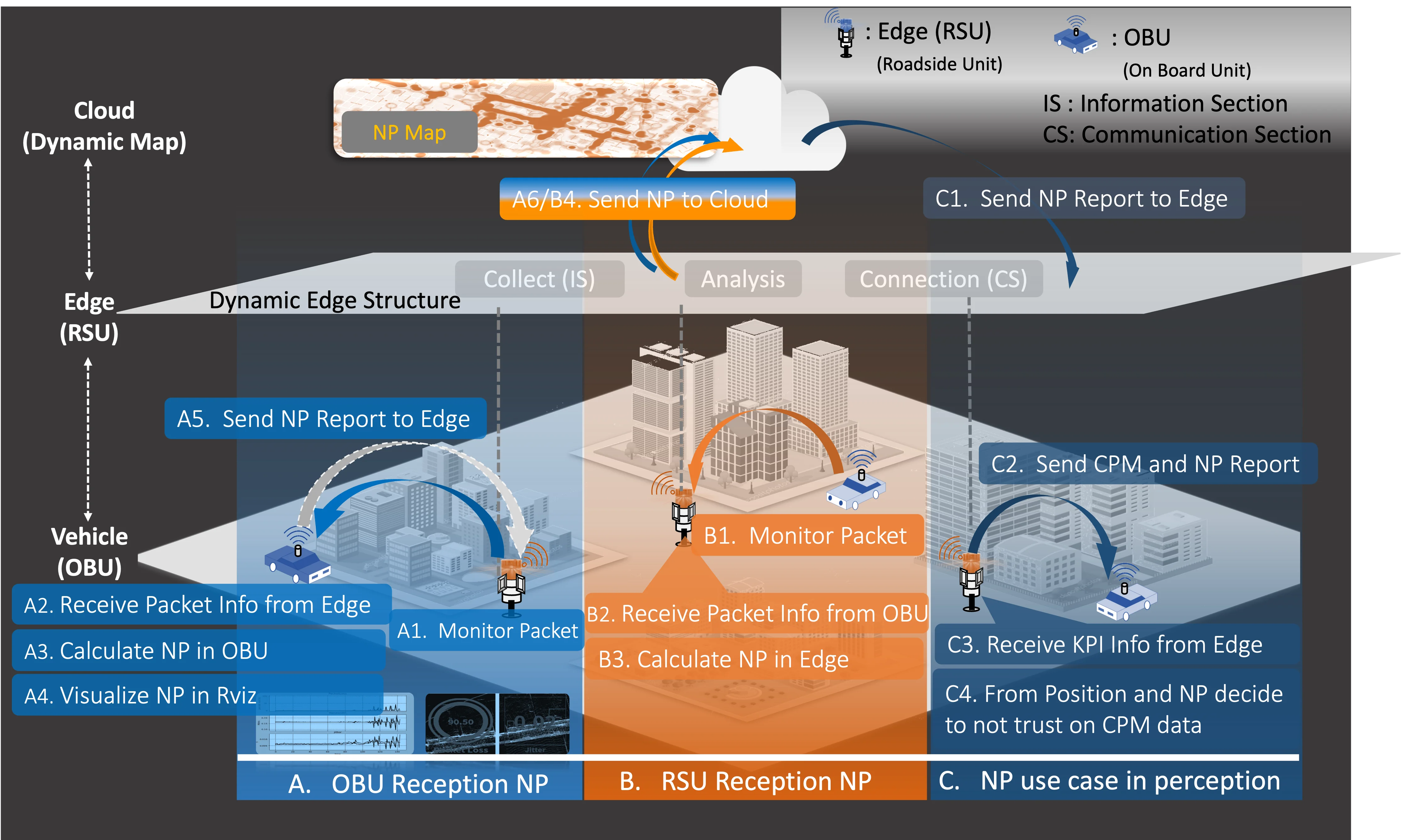
Abstract
Recently, connected autonomous vehicles (CAVs) have attracted increasing attention owing to their potential to improve traffic safety and increase traffic flow by utilizing vehicle-to-everything (V2X) communication capabilities. One of the key requirements for CAVs is ensuring that each vehicle sends/receives the message at the proper time and place; therefore, it is essential to meet the specific communication conditions for sending/receiving V2X messages. The analysis/visualization of measured data in CAVs is also indispensable. However, existing network analyzers for CAV applications do not consider geographic characteristics. This paper proposes a geographic-aware CAV-specific network analysis and visualization system that reports key real-time network performance indicators like packet loss, bandwidth, and jitter. We developed and evaluated a prototype of the system through two outdoor experiments conducted in dedicated and residential areas in Japan. We confirmed that the implemented systems were tied to geographic characteristics and successfully worked in the two areas. Furthermore, we analyzed multiple methods to interpolate data gaps in the data acquisition during the data acquisition period of CAVs caused by their velocity and demonstrated the effectiveness of propagation-based methods.
How to cite
K. Kambara, E. Javanmardi, J. Nakazato, S. Yamada, H. Takada, Y. Watanabe, K. Sato, and M. Tsukada, “Geographic-Aware Network Analysis and Visualization System for CAVs,” in International Conference on Intelligent Computing and its Emerging Applications (ICEA2024), Tokyo, Japan, 2024, doi: 10.1145/3732437.3732743.
BibTeX
@inproceedings{Kambara2024,
  title         = {Geographic-Aware Network Analysis and Visualization System for CAVs},
  author        = {Koichi Kambara and Ehsan Javanmardi and Jin Nakazato and Shunya Yamada and Hiroaki Takada and Yousuke Watanabe and Kenya Sato and Manabu Tsukada},
  doi           = {10.1145/3732437.3732743},
  year          = {2024},
  date          = {2024-11-28},
  urldate       = {2024-11-28},
  booktitle     = {International Conference on Intelligent Computing and its Emerging Applications (ICEA2024)},
  address       = {Tokyo, Japan},
  abstract      = {Recently, connected autonomous vehicles (CAVs) have attracted increasing attention owing to their potential to improve traffic safety and increase traffic flow by utilizing vehicle-to-everything (V2X) communication capabilities. One of the key requirements for CAVs is ensuring that each vehicle sends/receives the message at the proper time and place; therefore, it is essential to meet the specific communication conditions for sending/receiving V2X messages. The analysis/visualization of measured data in CAVs is also indispensable. However, existing network analyzers for CAV applications do not consider geographic characteristics. This paper proposes a geographic-aware CAV-specific network analysis and visualization system that reports key real-time network performance indicators like packet loss, bandwidth, and jitter. We developed and evaluated a prototype of the system through two outdoor experiments conducted in dedicated and residential areas in Japan. We confirmed that the implemented systems were tied to geographic characteristics and successfully worked in the two areas. Furthermore, we analyzed multiple methods to interpolate data gaps in the data acquisition during the data acquisition period of CAVs caused by their velocity and demonstrated the effectiveness of propagation-based methods.},
  keywords      = {ITS},
  pubstate      = {published},
  tppubtype     = {inproceedings}
}