
3D maps distribution of self-driving vehicles using roadside edges
Eighth International Symposium on Computing and Networking Workshops (CANDARW 2020), Okinawa, Japan, pp. 40–45, Nov 25, 2020
PDFDOI: 10.1109/CANDARW51189.2020.00021
Summary in three lines
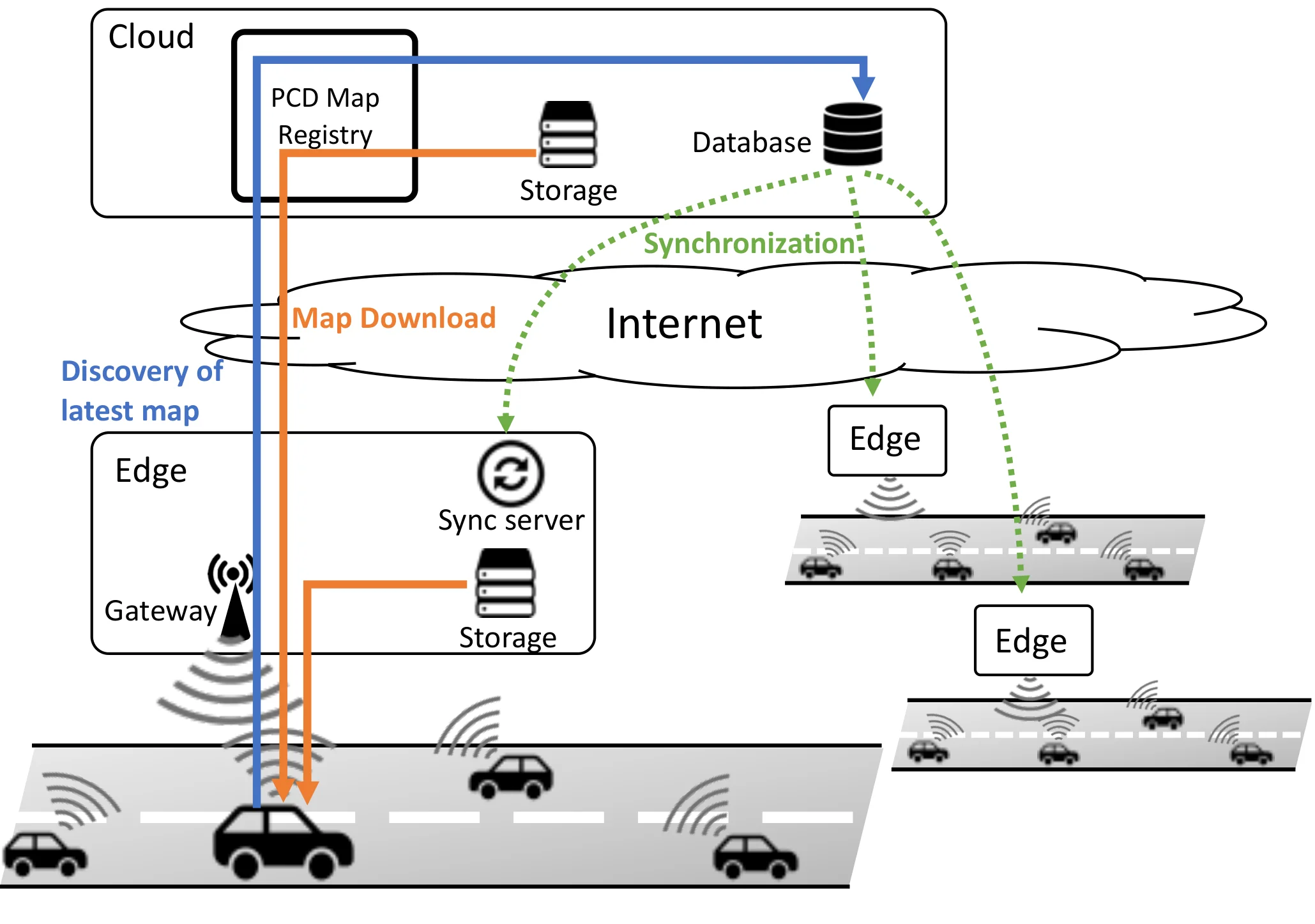
- The authors use roadside edge caches to deliver point-cloud maps as an automated vehicle travels.
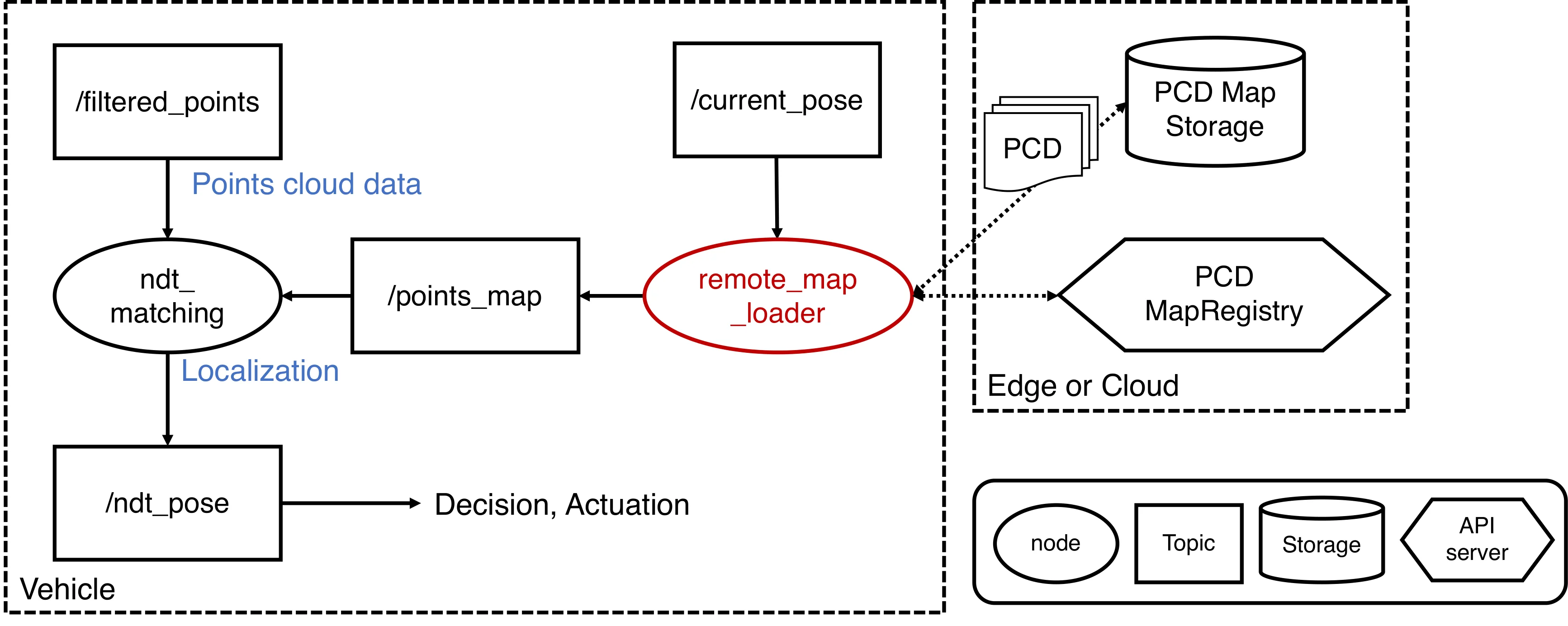
- Their Autoware implementation downloads map data while continuing to localize against the point cloud.
- Experiments varied bandwidth and found a maximum download time of 698 ms at 100 Mbps in the reported tests.
Figures from the paper
Abstract
Three-dimensional (3D) maps have become a shared digital infrastructure for autonomous vehicles, especially in urban areas. Point Cloud Data (PCD) maps are used for scan matching to enable self-localization. Autonomous vehicles need to maintain PCD maps along with the destination that is often decided on demand and to keep the PCD map updated. In this paper, we propose a system that delivers PCD maps cached at roadside edges in real time. We implement the system in Autoware, open-source software for autonomous driving. Subsequently, we evaluate whether the autonomous vehicle can simultaneously download the PCD map from its edge and enable self-localization. Our results show that autonomous vehicles can perform self-localization while downloading the PCD map from the edge server. Additionally, we measure the download time with variable bandwidth and examine the bandwidth in which the self-localization normally operates. In our results, the download time of the PCD map at 100 Mbps was 698 ms at maximum, and the possibility of downloading PCD maps through 4G communication is shown.
Video
How to cite
M. Mizutani, M. Tsukada, Y. Iida, and H. Esaki, “3D maps distribution of self-driving vehicles using roadside edges,” in Eighth International Symposium on Computing and Networking Workshops (CANDARW 2020), Okinawa, Japan, 2020, doi: 10.1109/CANDARW51189.2020.00021.
BibTeX
@workshop{Mizutani2020,
  title         = {3D maps distribution of self-driving vehicles using roadside edges},
  author        = {Masaya Mizutani and Manabu Tsukada and Yuki Iida and Hiroshi Esaki},
  url           = {https://hal.archives-ouvertes.fr/hal-02997520/document?.pdf https://youtu.be/JBuX3JKDVjA},
  doi           = {10.1109/CANDARW51189.2020.00021},
  year          = {2020},
  date          = {2020-11-25},
  urldate       = {2020-11-25},
  booktitle     = {Eighth International Symposium on Computing and Networking Workshops (CANDARW 2020)},
  pages         = {40--45},
  publisher     = {IEEE},
  address       = {Okinawa, Japan},
  abstract      = {Three-dimensional (3D) maps have become a shared digital infrastructure for autonomous vehicles, especially in urban areas. Point Cloud Data (PCD) maps are used for scan matching to enable self-localization. Autonomous vehicles need to maintain PCD maps along with the destination that is often decided on demand and to keep the PCD map updated. In this paper, we propose a system that delivers PCD maps cached at roadside edges in real time. We implement the system in Autoware, open-source software for autonomous driving. Subsequently, we evaluate whether the autonomous vehicle can simultaneously download the PCD map from its edge and enable self-localization. Our results show that autonomous vehicles can perform self-localization while downloading the PCD map from the edge server. Additionally, we measure the download time with variable bandwidth and examine the bandwidth in which the self-localization normally operates. In our results, the download time of the PCD map at 100 Mbps was 698 ms at maximum, and the possibility of downloading PCD maps through 4G communication is shown.},
  keywords      = {ITS},
  pubstate      = {published},
  tppubtype     = {workshop}
}