
Spatial ID-Driven Edge-Cloud Architecture for Real-Time Urban Digital Twins
IEEE 23rd Consumer Communications & Networking Conference (CCNC 2026), Las Vegas, NV, USA, 2026年1月8日
DOI: 10.1109/CCNC65079.2026.11366402
3行要約
- 階層的な4次元空間IDで、静的な都市モデルとリアルタイムのIoTデータを統合する。
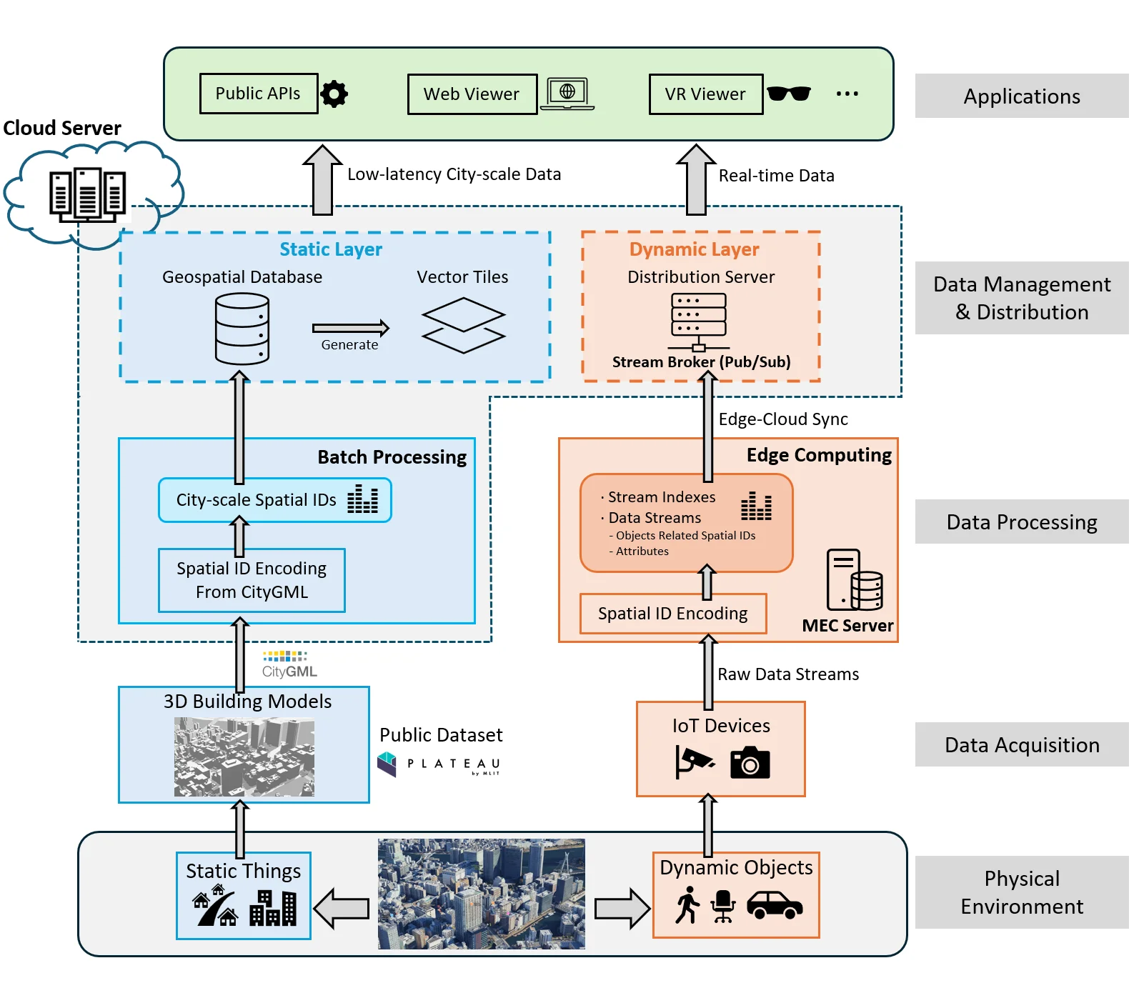
- エッジで観測ストリームを処理し、クラウドで静的な地理空間データと同期する。
- 千代田区と文京区の試作環境で、都市規模の可視化と空間クエリを実証した。
論文の図
アブストラクト(原文)
Only the chairs can edit The integration of static geospatial datasets and real-time IoT streams is essential for responsive and scalable urban Digital Twins (DTs). However, current infrastructures remain fragmented across domains, formats, and reference systems, limiting interoperability and city-scale deployment. This paper presents the first city-scale implementation of a Spatial ID-driven edge-cloud architecture that unifies heterogeneous static and dynamic urban data under a hierarchical four-dimensional identifier. Unlike prior DT systems that rely on ad hoc tiling or local schemas, our design operationalizes Spatial ID as a universal indexing layer across batch and streaming pipelines, enabling multi-resolution queries, real-time synchronization, and cross-domain interoperability. A prototype deployment in Tokyo's Chiyoda and Bunkyo wards demonstrates the approach, integrating 3D city models with live IoT streams. Static data are encoded into Spatial IDs and distributed via a geospatial database and vector tiles, while dynamic streams are processed at the edge and synchronized with a cloud backend using a publish/subscribe model. The system supports real-time encoding, querying, distribution, and web/Mixed Reality (MR)-based visualization. Evaluation shows millisecond-to-second query performance over 148 million records, sub-100 ms vector tile delivery, and real-time IoT stream processing at 30 fps. These results establish Spatial ID not only as a conceptual framework but as a practical, deployable foundation for interoperable, low-latency, and scalable Digital Twin infrastructures aligned with the vision of Society 5.0.
関連する研究・ソフトウェア
引用方法
Y. Chen, S. B. Djelloul, A. Orsholits, M. Tsukada, and H. Esaki, “Spatial ID-Driven Edge-Cloud Architecture for Real-Time Urban Digital Twins,” in IEEE 23rd Consumer Communications & Networking Conference (CCNC 2026), Las Vegas, NV, USA, 2026, doi: 10.1109/CCNC65079.2026.11366402.
BibTeX
@inproceedings{Chen2026,
  title         = {Spatial ID-Driven Edge-Cloud Architecture for Real-Time Urban Digital Twins},
  author        = {Yanru Chen and Sami Brahim Djelloul and Alex Orsholits and Manabu Tsukada and Hiroshi Esaki},
  doi           = {10.1109/CCNC65079.2026.11366402},
  year          = {2026},
  date          = {2026-01-08},
  urldate       = {2026-01-08},
  booktitle     = {IEEE 23rd Consumer Communications & Networking Conference (CCNC 2026)},
  address       = {Las Vegas, NV, USA},
  abstract      = {Only the chairs can edit The integration of static geospatial datasets and real-time IoT streams is essential for responsive and scalable urban Digital Twins (DTs). However, current infrastructures remain fragmented across domains, formats, and reference systems, limiting interoperability and city-scale deployment. This paper presents the first city-scale implementation of a Spatial ID-driven edge-cloud architecture that unifies heterogeneous static and dynamic urban data under a hierarchical four-dimensional identifier. Unlike prior DT systems that rely on ad hoc tiling or local schemas, our design operationalizes Spatial ID as a universal indexing layer across batch and streaming pipelines, enabling multi-resolution queries, real-time synchronization, and cross-domain interoperability. A prototype deployment in Tokyo's Chiyoda and Bunkyo wards demonstrates the approach, integrating 3D city models with live IoT streams. Static data are encoded into Spatial IDs and distributed via a geospatial database and vector tiles, while dynamic streams are processed at the edge and synchronized with a cloud backend using a publish/subscribe model. The system supports real-time encoding, querying, distribution, and web/Mixed Reality (MR)-based visualization. Evaluation shows millisecond-to-second query performance over 148 million records, sub-100 ms vector tile delivery, and real-time IoT stream processing at 30 fps. These results establish Spatial ID not only as a conceptual framework but as a practical, deployable foundation for interoperable, low-latency, and scalable Digital Twin infrastructures aligned with the vision of Society 5.0.},
  keywords      = {SDM},
  pubstate      = {published},
  tppubtype     = {inproceedings}
}