
Spatial ID-Driven Edge-Cloud Architecture for Real-Time Urban Digital Twins
IEEE 23rd Consumer Communications & Networking Conference (CCNC 2026), Las Vegas, NV, USA, Jan 8, 2026
DOI: 10.1109/CCNC65079.2026.11366402
Summary in three lines
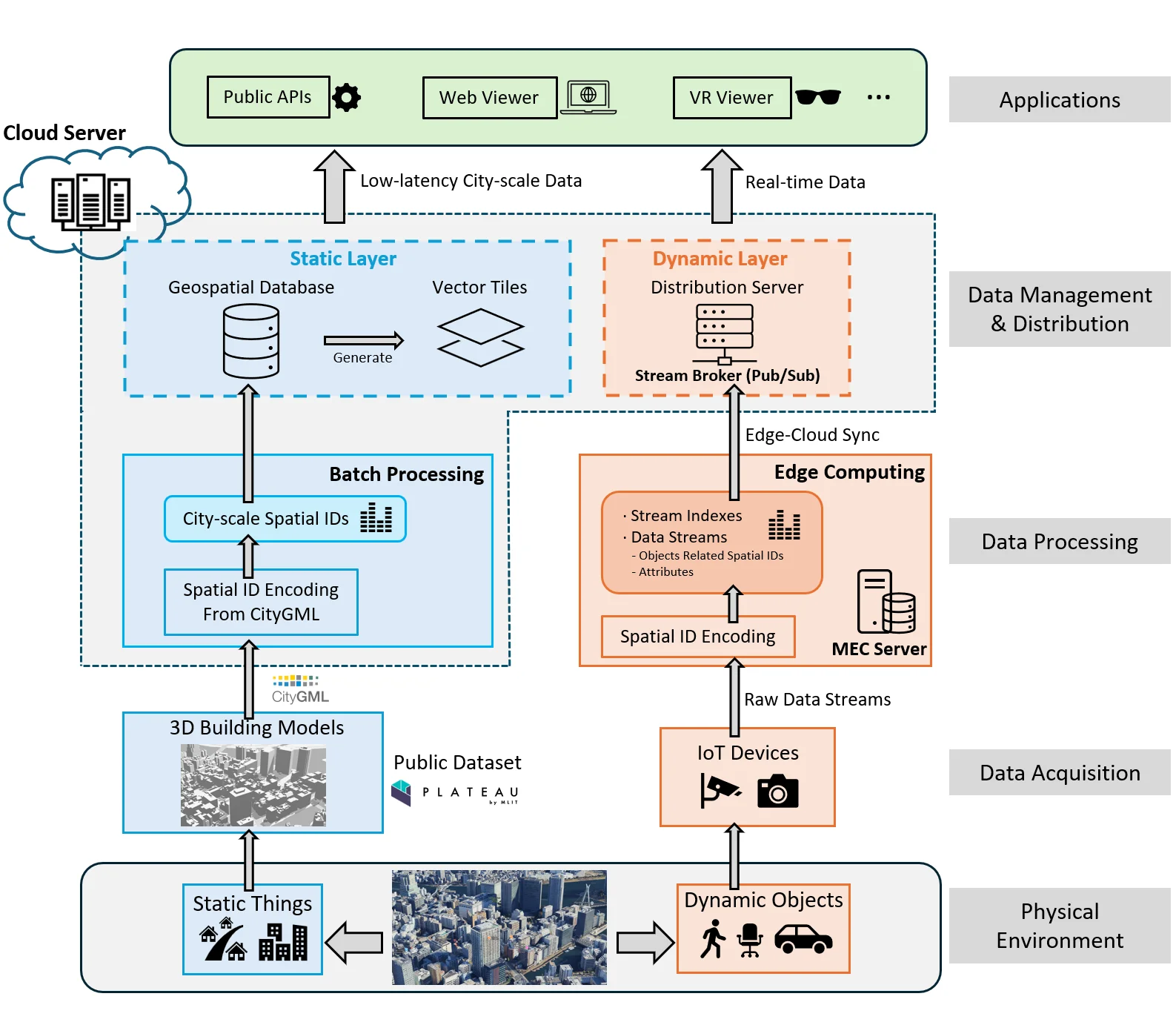
- This edge–cloud architecture joins static city models and live IoT streams through hierarchical four-dimensional Spatial IDs.
- Edge nodes process streaming observations and cloud services synchronize them with geospatial data.
- A prototype in Tokyo’s Chiyoda and Bunkyo wards demonstrates city-scale visualization and spatial queries.
Figures from the paper
Abstract
Only the chairs can edit The integration of static geospatial datasets and real-time IoT streams is essential for responsive and scalable urban Digital Twins (DTs). However, current infrastructures remain fragmented across domains, formats, and reference systems, limiting interoperability and city-scale deployment. This paper presents the first city-scale implementation of a Spatial ID-driven edge-cloud architecture that unifies heterogeneous static and dynamic urban data under a hierarchical four-dimensional identifier. Unlike prior DT systems that rely on ad hoc tiling or local schemas, our design operationalizes Spatial ID as a universal indexing layer across batch and streaming pipelines, enabling multi-resolution queries, real-time synchronization, and cross-domain interoperability. A prototype deployment in Tokyo's Chiyoda and Bunkyo wards demonstrates the approach, integrating 3D city models with live IoT streams. Static data are encoded into Spatial IDs and distributed via a geospatial database and vector tiles, while dynamic streams are processed at the edge and synchronized with a cloud backend using a publish/subscribe model. The system supports real-time encoding, querying, distribution, and web/Mixed Reality (MR)-based visualization. Evaluation shows millisecond-to-second query performance over 148 million records, sub-100 ms vector tile delivery, and real-time IoT stream processing at 30 fps. These results establish Spatial ID not only as a conceptual framework but as a practical, deployable foundation for interoperable, low-latency, and scalable Digital Twin infrastructures aligned with the vision of Society 5.0.
Related research and software
How to cite
Y. Chen, S. B. Djelloul, A. Orsholits, M. Tsukada, and H. Esaki, “Spatial ID-Driven Edge-Cloud Architecture for Real-Time Urban Digital Twins,” in IEEE 23rd Consumer Communications & Networking Conference (CCNC 2026), Las Vegas, NV, USA, 2026, doi: 10.1109/CCNC65079.2026.11366402.
BibTeX
@inproceedings{Chen2026,
  title         = {Spatial ID-Driven Edge-Cloud Architecture for Real-Time Urban Digital Twins},
  author        = {Yanru Chen and Sami Brahim Djelloul and Alex Orsholits and Manabu Tsukada and Hiroshi Esaki},
  doi           = {10.1109/CCNC65079.2026.11366402},
  year          = {2026},
  date          = {2026-01-08},
  urldate       = {2026-01-08},
  booktitle     = {IEEE 23rd Consumer Communications & Networking Conference (CCNC 2026)},
  address       = {Las Vegas, NV, USA},
  abstract      = {Only the chairs can edit The integration of static geospatial datasets and real-time IoT streams is essential for responsive and scalable urban Digital Twins (DTs). However, current infrastructures remain fragmented across domains, formats, and reference systems, limiting interoperability and city-scale deployment. This paper presents the first city-scale implementation of a Spatial ID-driven edge-cloud architecture that unifies heterogeneous static and dynamic urban data under a hierarchical four-dimensional identifier. Unlike prior DT systems that rely on ad hoc tiling or local schemas, our design operationalizes Spatial ID as a universal indexing layer across batch and streaming pipelines, enabling multi-resolution queries, real-time synchronization, and cross-domain interoperability. A prototype deployment in Tokyo's Chiyoda and Bunkyo wards demonstrates the approach, integrating 3D city models with live IoT streams. Static data are encoded into Spatial IDs and distributed via a geospatial database and vector tiles, while dynamic streams are processed at the edge and synchronized with a cloud backend using a publish/subscribe model. The system supports real-time encoding, querying, distribution, and web/Mixed Reality (MR)-based visualization. Evaluation shows millisecond-to-second query performance over 148 million records, sub-100 ms vector tile delivery, and real-time IoT stream processing at 30 fps. These results establish Spatial ID not only as a conceptual framework but as a practical, deployable foundation for interoperable, low-latency, and scalable Digital Twin infrastructures aligned with the vision of Society 5.0.},
  keywords      = {SDM},
  pubstate      = {published},
  tppubtype     = {inproceedings}
}