
A Scalable Spatial ID-Driven Infrastructure for Unified Urban Digital Twins and Spatial Computing
Master Thesis, Graduate School of Information Science and Technology, The University of Tokyo (Esaki Lab), 2026年3月31日
3行要約
- 4次元の空間IDで静的な都市データと高頻度のIoT観測を結び付ける。
- エッジでボクセル化を行い、クラウドで静的な地理情報と最新の状態を配信する。
- 試作システムで、都市規模の状況把握における1秒未満の応答と帯域削減を示した。
論文の図
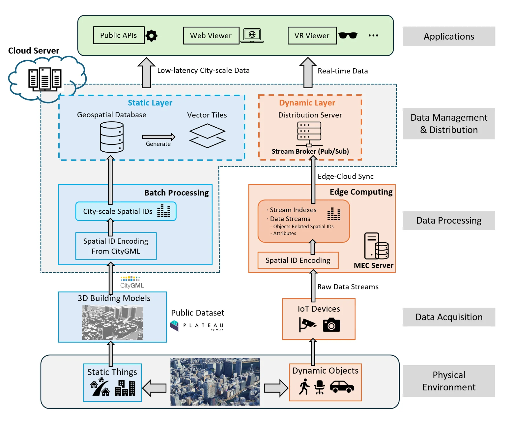
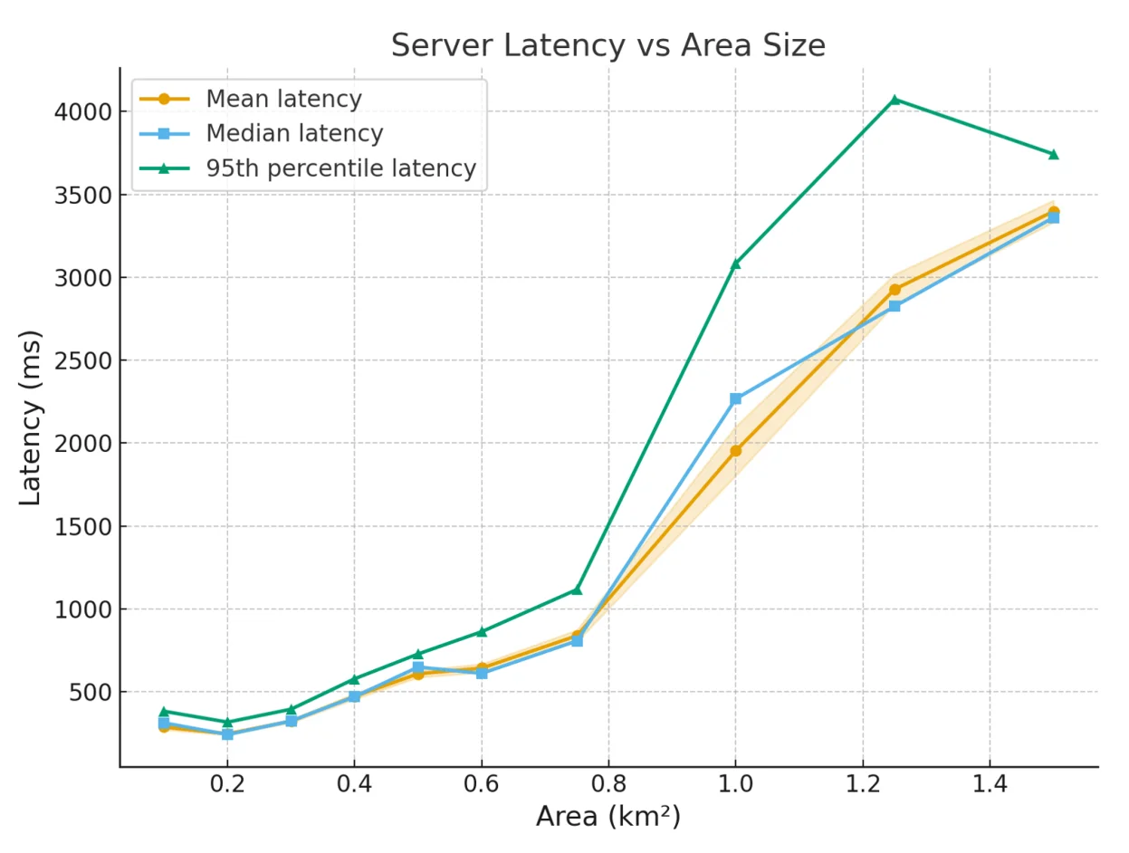
アブストラクト(原文)
The transition from static 3D city models to operational Urban Digital Twins is a primary objective of Japan’s Society 5.0 strategy. A synchronization barrier currently prevents the real-time integration of archival geospatial layers with high-frequency IoT data. This research proposes a scalable infrastructure driven by Spatial IDs to bridge this gap. The system utilizes a natively 4D voxel-based framework as a universal join key for urban spatial computing. This infrastructure addresses fundamental technical hurdles, such as inconsistent spatial referencing and the lack of real-time operational awareness and response. Moving intensive voxelization tasks to the network edge establishes a decentralized computing model. This architecture delivers sub-second response times for situational awareness. It significantly reduces the network bandwidth required for city-scale deployments. A cloud-native distribution framework manages this intelligence through a geospatial database. This database delivers static urban structures via traditional api endpoints and optimized vector tiles. It broadcasts dynamic states through a real-time stream broker. Performance evaluations in realistic urban environments demonstrate that the system maintains interactive responsiveness. It also ensures high-accuracy semantic extraction. These features allow the digital twin to function as a live mirror of the physical environ- ment. A Mixed Reality platform validates the practical utility of this infrastructure. The platform enables geospatial anchoring. It also supports real-time visualization. Users interact with a standardized 3D grid to facilitate collaborative decision-making. This research establishes a scalable foundation for interoperable urban digital twins. It unifies static models and dynamic streams within a single machine-readable frame. Ultimately, by establishing the Spatial ID as a universal join key, this research trans- forms the urban digital twin from a static, retrospective archive into an active, operational layer of the city’s nervous system. The seamless integration of edge-cloud processing and immersive visualization provides a trustworthy backbone for future smart city services, where physical movements and digital insights coexist within a single, high-fidelity frame. This establishes continuity not only to resolve the immediate synchronization barrier but also to lay the groundwork for a standardized, cross-platform ecosystem where spatial intelligence is accessible, persistent, and actionable at a national scale.
引用方法
Y. Chen, “A Scalable Spatial ID-Driven Infrastructure for Unified Urban Digital Twins and Spatial Computing,” in Master Thesis, Graduate School of Information Science and Technology, The University of Tokyo (Esaki Lab), 2026.
BibTeX
@mastersthesis{Yanru2026,
  title         = {A Scalable Spatial ID-Driven Infrastructure for Unified Urban Digital Twins and Spatial Computing},
  author        = {Yanru Chen},
  year          = {2026},
  date          = {2026-03-31},
  urldate       = {2026-03-31},
  school        = {Master Thesis, Graduate School of Information Science and Technology, The University of Tokyo (Esaki Lab)},
  abstract      = {The transition from static 3D city models to operational Urban Digital Twins is a primary objective of Japan’s Society 5.0 strategy. A synchronization barrier currently prevents the real-time integration of archival geospatial layers with high-frequency IoT data. This research proposes a scalable infrastructure driven by Spatial IDs to bridge this gap. The system utilizes a natively 4D voxel-based framework as a universal join key for urban spatial computing. This infrastructure addresses fundamental technical hurdles, such as inconsistent spatial referencing and the lack of real-time operational awareness and response. Moving intensive voxelization tasks to the network edge establishes a decentralized computing model. This architecture delivers sub-second response times for situational awareness. It significantly reduces the network bandwidth required for city-scale deployments. A cloud-native distribution framework manages this intelligence through a geospatial database. This database delivers static urban structures via traditional api endpoints and optimized vector tiles. It broadcasts dynamic states through a real-time stream broker. Performance evaluations in realistic urban environments demonstrate that the system maintains interactive responsiveness. It also ensures high-accuracy semantic extraction. These features allow the digital twin to function as a live mirror of the physical environ- ment. A Mixed Reality platform validates the practical utility of this infrastructure. The platform enables geospatial anchoring. It also supports real-time visualization. Users interact with a standardized 3D grid to facilitate collaborative decision-making. This research establishes a scalable foundation for interoperable urban digital twins. It unifies static models and dynamic streams within a single machine-readable frame. Ultimately, by establishing the Spatial ID as a universal join key, this research trans- forms the urban digital twin from a static, retrospective archive into an active, operational layer of the city’s nervous system. The seamless integration of edge-cloud processing and immersive visualization provides a trustworthy backbone for future smart city services, where physical movements and digital insights coexist within a single, high-fidelity frame. This establishes continuity not only to resolve the immediate synchronization barrier but also to lay the groundwork for a standardized, cross-platform ecosystem where spatial intelligence is accessible, persistent, and actionable at a national scale.},
  keywords      = {Thesis},
  pubstate      = {published},
  tppubtype     = {mastersthesis}
}