
A Scalable Spatial ID-Driven Infrastructure for Unified Urban Digital Twins and Spatial Computing
Master Thesis, Graduate School of Information Science and Technology, The University of Tokyo (Esaki Lab), Mar 31, 2026
Summary in three lines
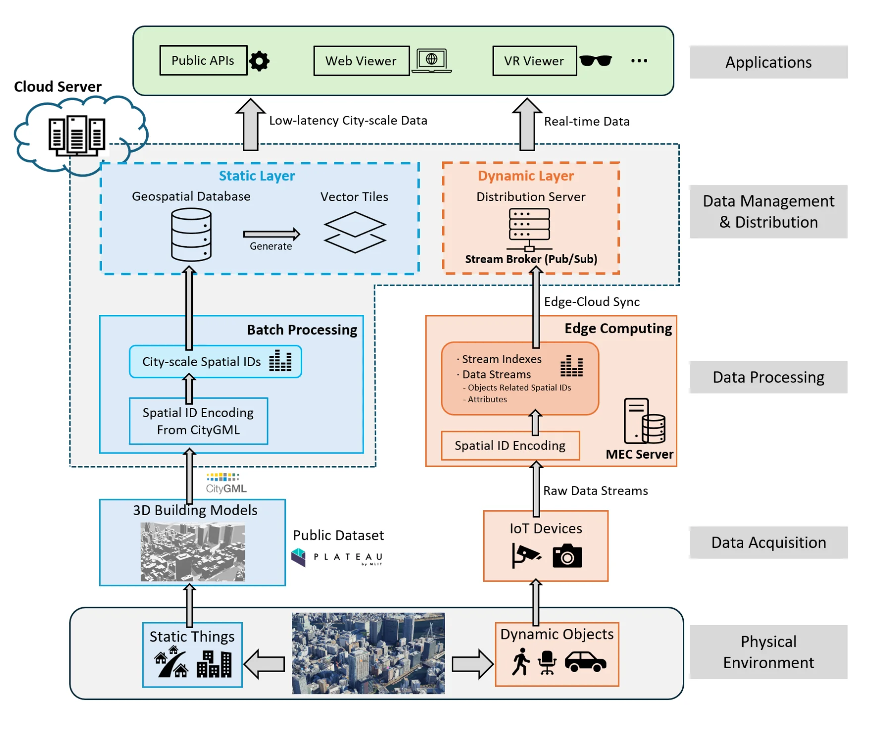
- The thesis uses four-dimensional Spatial IDs to join archival city data with high-frequency IoT observations.
- Voxel processing runs at the edge, while cloud services distribute static geospatial data and live updates.
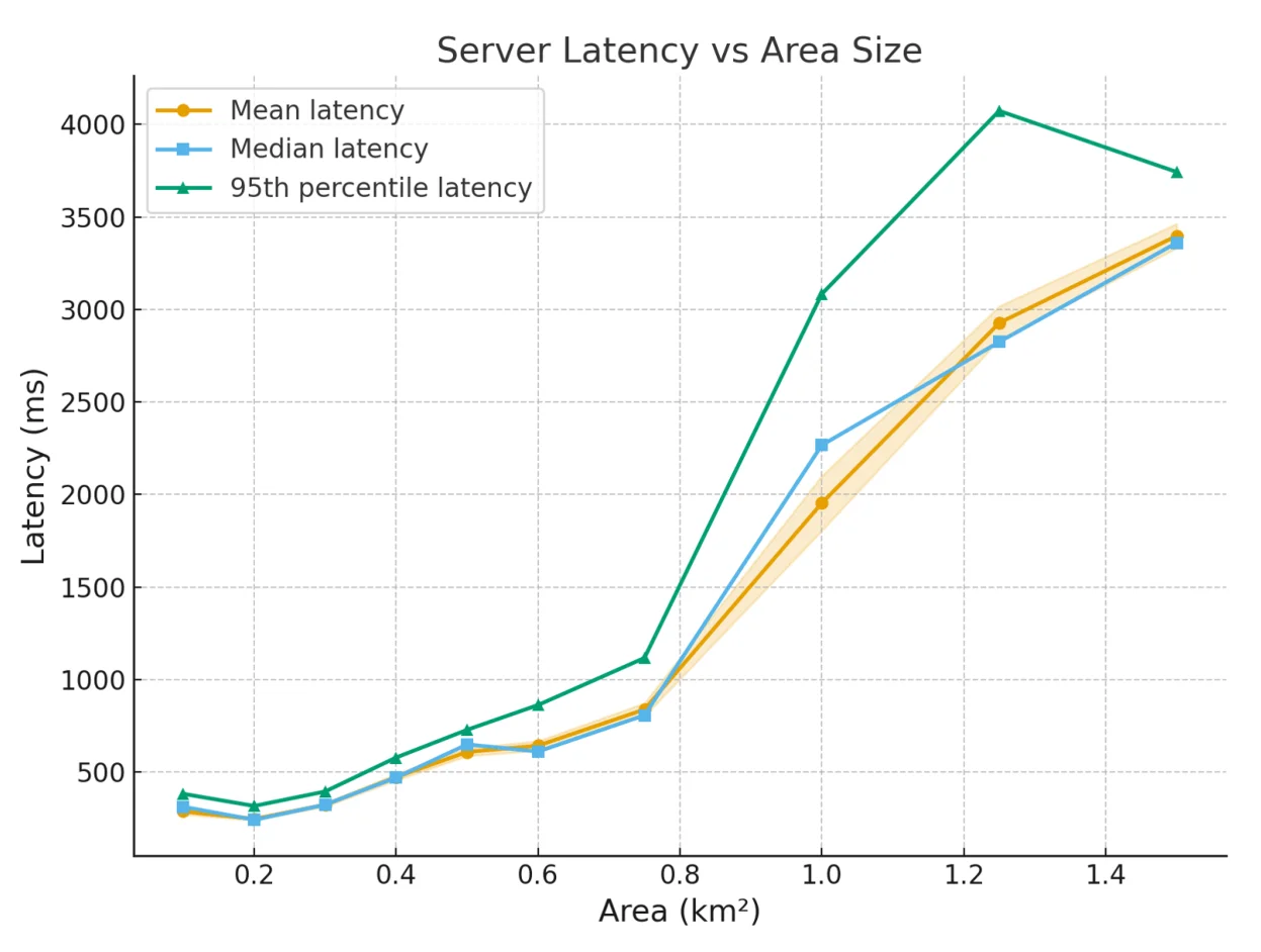
- The prototype demonstrates sub-second situational-awareness responses and reduced bandwidth for urban-scale operation.
Figures from the paper
Abstract
The transition from static 3D city models to operational Urban Digital Twins is a primary objective of Japan’s Society 5.0 strategy. A synchronization barrier currently prevents the real-time integration of archival geospatial layers with high-frequency IoT data. This research proposes a scalable infrastructure driven by Spatial IDs to bridge this gap. The system utilizes a natively 4D voxel-based framework as a universal join key for urban spatial computing. This infrastructure addresses fundamental technical hurdles, such as inconsistent spatial referencing and the lack of real-time operational awareness and response. Moving intensive voxelization tasks to the network edge establishes a decentralized computing model. This architecture delivers sub-second response times for situational awareness. It significantly reduces the network bandwidth required for city-scale deployments. A cloud-native distribution framework manages this intelligence through a geospatial database. This database delivers static urban structures via traditional api endpoints and optimized vector tiles. It broadcasts dynamic states through a real-time stream broker. Performance evaluations in realistic urban environments demonstrate that the system maintains interactive responsiveness. It also ensures high-accuracy semantic extraction. These features allow the digital twin to function as a live mirror of the physical environ- ment. A Mixed Reality platform validates the practical utility of this infrastructure. The platform enables geospatial anchoring. It also supports real-time visualization. Users interact with a standardized 3D grid to facilitate collaborative decision-making. This research establishes a scalable foundation for interoperable urban digital twins. It unifies static models and dynamic streams within a single machine-readable frame. Ultimately, by establishing the Spatial ID as a universal join key, this research trans- forms the urban digital twin from a static, retrospective archive into an active, operational layer of the city’s nervous system. The seamless integration of edge-cloud processing and immersive visualization provides a trustworthy backbone for future smart city services, where physical movements and digital insights coexist within a single, high-fidelity frame. This establishes continuity not only to resolve the immediate synchronization barrier but also to lay the groundwork for a standardized, cross-platform ecosystem where spatial intelligence is accessible, persistent, and actionable at a national scale.
How to cite
Y. Chen, “A Scalable Spatial ID-Driven Infrastructure for Unified Urban Digital Twins and Spatial Computing,” in Master Thesis, Graduate School of Information Science and Technology, The University of Tokyo (Esaki Lab), 2026.
BibTeX
@mastersthesis{Yanru2026,
  title         = {A Scalable Spatial ID-Driven Infrastructure for Unified Urban Digital Twins and Spatial Computing},
  author        = {Yanru Chen},
  year          = {2026},
  date          = {2026-03-31},
  urldate       = {2026-03-31},
  school        = {Master Thesis, Graduate School of Information Science and Technology, The University of Tokyo (Esaki Lab)},
  abstract      = {The transition from static 3D city models to operational Urban Digital Twins is a primary objective of Japan’s Society 5.0 strategy. A synchronization barrier currently prevents the real-time integration of archival geospatial layers with high-frequency IoT data. This research proposes a scalable infrastructure driven by Spatial IDs to bridge this gap. The system utilizes a natively 4D voxel-based framework as a universal join key for urban spatial computing. This infrastructure addresses fundamental technical hurdles, such as inconsistent spatial referencing and the lack of real-time operational awareness and response. Moving intensive voxelization tasks to the network edge establishes a decentralized computing model. This architecture delivers sub-second response times for situational awareness. It significantly reduces the network bandwidth required for city-scale deployments. A cloud-native distribution framework manages this intelligence through a geospatial database. This database delivers static urban structures via traditional api endpoints and optimized vector tiles. It broadcasts dynamic states through a real-time stream broker. Performance evaluations in realistic urban environments demonstrate that the system maintains interactive responsiveness. It also ensures high-accuracy semantic extraction. These features allow the digital twin to function as a live mirror of the physical environ- ment. A Mixed Reality platform validates the practical utility of this infrastructure. The platform enables geospatial anchoring. It also supports real-time visualization. Users interact with a standardized 3D grid to facilitate collaborative decision-making. This research establishes a scalable foundation for interoperable urban digital twins. It unifies static models and dynamic streams within a single machine-readable frame. Ultimately, by establishing the Spatial ID as a universal join key, this research trans- forms the urban digital twin from a static, retrospective archive into an active, operational layer of the city’s nervous system. The seamless integration of edge-cloud processing and immersive visualization provides a trustworthy backbone for future smart city services, where physical movements and digital insights coexist within a single, high-fidelity frame. This establishes continuity not only to resolve the immediate synchronization barrier but also to lay the groundwork for a standardized, cross-platform ecosystem where spatial intelligence is accessible, persistent, and actionable at a national scale.},
  keywords      = {Thesis},
  pubstate      = {published},
  tppubtype     = {mastersthesis}
}