
Spatial ID Authoring in Mixed Reality: A Unified Platform Integrating Anchoring and Visualization
IEEE International Conference on Artificial Intelligence and Virtual Reality (AIxVR 2026), Work in Progress (WiP), Osaka, Japan, Jan 26, 2026
DOI: 10.1109/AIxVR67263.2026.00045
Summary in three lines
- This mixed-reality platform uses Spatial IDs as common references for digital content anchored in the physical world.
- A spatial index links grid cells to annotations and live data across applications and devices.
- The prototype aligns a headset to the environment and visualizes detected objects and authored labels in place.
Figures from the paper
Abstract
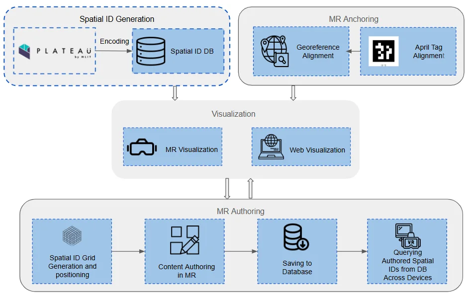
We present a Mixed Reality (MR) authoring platform that leverages Spatial IDs as a standardized reference to align digital content with the physical environment. The platform enables users to tag and annotate space through Spatial IDs, with annotations managed through a decoupled architecture where a queryable Spatial ID index links spatial entities to external databases containing attributes and application-specific content. To support this, we integrate two enabling components. First, anchoring: Spatial IDs provide a hierarchical four-dimensional indexing system that ensures consistent alignment across datasets and localization methods. Second, visualization: anchored Spatial IDs allow both real-world data streams and authored datasets to be rendered in MR. As a proof of concept, we integrate cloud-based object detection from an external depth camera, streaming recognized objects into MR and visualizing them at their true physical locations. Together, these components demonstrate how Spatial IDs enable accurate visualization and persistent authoring, offering a unified pipeline for next-generation spatial computing.
Related research and software
How to cite
S. B. Djelloul, Y. Chen, A. Orsholits, and M. Tsukada, “Spatial ID Authoring in Mixed Reality: A Unified Platform Integrating Anchoring and Visualization,” in IEEE International Conference on Artificial Intelligence and Virtual Reality (AIxVR 2026), Work in Progress (WiP), Osaka, Japan, 2026, doi: 10.1109/AIxVR67263.2026.00045.
BibTeX
@inproceedings{Djelloul2026,
  title         = {Spatial ID Authoring in Mixed Reality: A Unified Platform Integrating Anchoring and Visualization},
  author        = {Sami Brahim Djelloul and Yanru Chen and Alex Orsholits and Manabu Tsukada},
  doi           = {10.1109/AIxVR67263.2026.00045},
  year          = {2026},
  date          = {2026-01-26},
  urldate       = {2026-01-26},
  booktitle     = {IEEE International Conference on Artificial Intelligence and Virtual Reality (AIxVR 2026), Work in Progress (WiP)},
  address       = {Osaka, Japan},
  abstract      = {We present a Mixed Reality (MR) authoring platform that leverages Spatial IDs as a standardized reference to align digital content with the physical environment. The platform enables users to tag and annotate space through Spatial IDs, with annotations managed through a decoupled architecture where a queryable Spatial ID index links spatial entities to external databases containing attributes and application-specific content. To support this, we integrate two enabling components. First, anchoring: Spatial IDs provide a hierarchical four-dimensional indexing system that ensures consistent alignment across datasets and localization methods. Second, visualization: anchored Spatial IDs allow both real-world data streams and authored datasets to be rendered in MR. As a proof of concept, we integrate cloud-based object detection from an external depth camera, streaming recognized objects into MR and visualizing them at their true physical locations. Together, these components demonstrate how Spatial IDs enable accurate visualization and persistent authoring, offering a unified pipeline for next-generation spatial computing.},
  keywords      = {SDM},
  pubstate      = {published},
  tppubtype     = {inproceedings}
}