0%

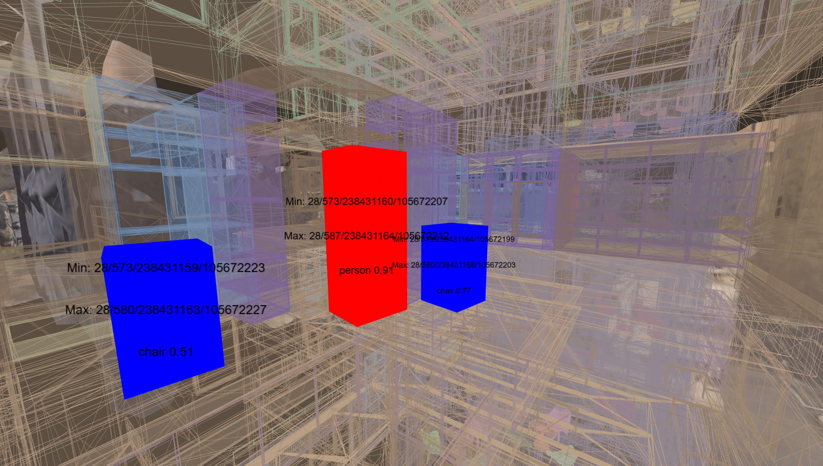


Spatial ID is a Japanese government–defined standard that represents physical space as a hierarchical grid of three-dimensional voxels, optionally extended along the time axis. Each voxel is assigned a computable identifier in the form {z}/{f}/{x}/{y} (zoom level / altitude / longitude / latitude), enabling consistent addressing from planetary scale down to fine spatial resolutions, including sub-meter voxels (approximately 15 cm at high zoom levels, such as ZL28). By abstracting space into a unified identifier system, Spatial ID allows heterogeneous datasets—static or dynamic, spatial or temporal—to be indexed, queried, and integrated using conventional database mechanisms rather than application-specific GIS pipelines. In this sense, Spatial ID functions not merely as a spatial representation, but as an addressable and queryable framework for large-scale spatial computing.
One line of our research examines how Spatial ID can be used as a spatial authoring and referencing mechanism, with Mixed Reality (MR) systems employed as an interface for interacting with physical space. In this work, Spatial IDs function as persistent anchors that bind digital content—such as annotations, attributes, and sensor-derived data—to real-world locations. These associations are managed through a decoupled database architecture, enabling flexible retrieval and cross-platform interoperability. By integrating cloud-based perception pipelines and visualizing their outputs in MR at the corresponding physical locations, this research demonstrates how Spatial ID supports accurate spatial alignment, persistent authoring, and real-time inspection. In this work, Mixed Reality is used as an interface layer for spatial authoring and inspection, allowing Spatial ID–indexed data to be created, validated, and explored directly in physical space.
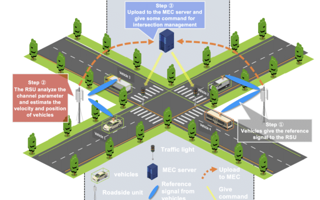
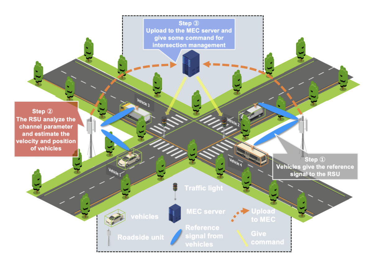
At a larger scale, our research focuses on operating Spatial ID as the core indexing layer of real-time urban data infrastructures. Static city models derived from Project PLATEAU are encoded into Spatial IDs and distributed via geospatial databases and vector tiles, while dynamic IoT streams are processed at the edge, encoded into Spatial IDs in real time, and synchronized with cloud services using publish–subscribe mechanisms. This edge–cloud architecture enables database-style queries and subscriptions over four-dimensional data (space and time), supporting low-latency access from web-based and immersive clients. City-scale deployments in Tokyo demonstrate that Spatial ID can unify static and dynamic urban data within a single operational framework, rather than as loosely coupled, application-specific pipelines.
Our future focus is the deployment of a high-performance Spatial ID database architecture capable of supporting near-instantaneous queries at metropolitan scale, including public operation of the database as an openly accessible infrastructure. Several challenges become dominant at this scale. First, at high zoom levels, the number of Spatial IDs grows extremely quickly as query area increases; even modest increases in area can lead to exponential growth in query time and I/O, making large-area, high-resolution queries impractical unless strict area constraints and query policies are enforced. Second, dataset size is a fundamental constraint: a full Spatial ID dataset for Tokyo’s 23 wards at ZL25 already exceeds 150 GB in raw form, effectively ruling out single-server deployments and requiring distributed compute, indexing strategies, and infrastructure-level design to support even the most basic queries. The most difficult problem, however, is defining what data should be queryable at which zoom level. Fine-grained data such as individual sensor locations or detailed metadata may be appropriate at building or street scale, but exposing the same data to city- or region-scale queries would require aggregating enormous numbers of records and would not scale. As a result, the data ingest model itself must incorporate zoom-level–dependent data availability, aggregation, and compaction policies. Addressing these issues is essential to establishing Spatial ID as a practical, trustworthy indexing backbone compatible with existing computing systems and future spatial computing workloads.
v2x

digital twins extended reality

digital twins

autonomous driving machine learning

machine learning v2x

autonomous driving v2x

extended reality

v2x